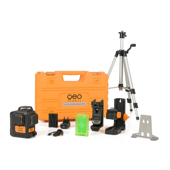
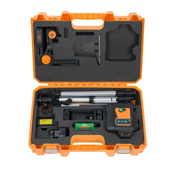
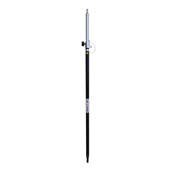
GeoMax ZPC201 Telescopic Carbon Fiber...
GeoMax ZPC201 Telescopic Carbon Fiber and Aluminum Pole for TPS
Filter By
Brand
Brand
Price
Price
Use
Use
Horizontal circle
Horizontal circle
Magnification
Magnification
Single Prism Range
Single Prism Range
Reflectorless Range
Reflectorless Range
Accuracy at 1 km double leveling
Scope Magnification
Scope Magnification
Laser Beam
Laser Beam
Tilt Sensor
Tilt Sensor
Model
Model
Included Sensor
Included Sensor
Channels
Channels
UHF Radio modem
UHF Radio modem
Screen
Screen
Receiver for use with
Pole for use with
Pole for use with
Level Type
Level Type
Range
Range
Accuracy (mm to 10 meters)
Automatic Level Set
Automatic Level Set
Laser Type
Laser Type
Touchscreen
Touchscreen
IMU
IMU
Slope Setting
Slope Setting
Type
Type
Total Station Type
Total Station Type
Angle measurement accuracy
Working Range with Receiver Ø
Horizontal Levelling
Vertical Levelling
Vertical Levelling
Optical Plummet
Optical Plummet
GeoMax ZPC201 Telescopic Carbon Fiber and Aluminum Pole for TPS
The Geomax ZAL232 Automatic Level is ideal for surveyors, construction professionals, builders and civil engineers for all daily levelling tasks and 360-degree horizontal angle measurements. This optical instrument features a rugged design, top-class optics, and an internal compensator to avoid readjustments, with 1/8 inch accuracy making it perfect for landscaping, fence building, layout and more.
Highlights
-Navis-LiveData Advance Access 3 years-
Navis LiveData is cloud based web portal that allows viewing data form multiple Navis wireless wind sensors. It works by connecting Navis wireless wind sensors to Navis LiveData capable devices. Devices transmit data to Navis LiveData web interface. Data can be viewed globally on web browser using URL https://www.navis-livedata.com/.
The perfect one - mm-indication & extra long receiving window
The geo-FENNEL FR 80-MM laser receiver features a digital laser height display in mm, an extra-long 120 mm reception field and is ideal for rotary lasers with a red or green laser beam.Like other receivers in this series, the FR 80-MM is characterized by its robustness in accordance with IP67. The easy-to-read, illuminated display with LED indicator and the metal retaining clip for the leveling staff offer the user the best possible working conditions, and the FR 80-MM is the only receiver in this series that allows the user to freely define the "0" position (offset).
-Say hello to the new member of the 6X product family-
Entry-level device in the usual professional geo-FENNEL quality. Slightly reduced scope in technical data and accessories compared to Geo6X-GREEN.
-Say hello to the new member of the 6X product family-
Entry-level device in the usual professional geo-FENNEL quality. Slightly reduced scope in technical data and accessories compared to Geo6X-GREEN.
For use with TRACKING Rotating Lasers FLG 245HV GREEN TRACKING, FL 275HV TRACKING, FL 510HV-G TRACKING
The geo-FENNEL FR 80-MM TRACKING has an extra-long reception field of 120mm, a very robust housing, an easy-to-read display and a sturdy metal bracket for the leveling staff. The FR 80-MM also impresses with its specially developed monitoring function for geo-FENNEL TRACKING rotating lasers, such as the FLG 245HV GREEN, TRACKING, FL275HV TRACKING and the FL 510HV-GTRACKING. Once the tracking process is complete, the tracked axis is continuously monitored by a permanent radio link between the laser and receiver.
GeoMax ZAL232 Automatic Level Package with Tripod & Levelling Staff.
Includes:
-Say hello to the new member of the 6X product family-
Entry-level device in the usual professional geo-FENNEL quality. Slightly reduced scope in technical data and accessories compared to Geo6X-GREEN.
Navis W210 is a wireless anemometer with audible and visual alarm. It has a range of up to 400 meters of visible distance. Includes the WS 010-1 wind speed sensor.
Geo-Fennel FTI 400 Professional thermal imaging camera with IR sensor resolution of 120 x 160 pixels. 2.8-inch display, temperature range from -20 to +400°C. Many image modes/color palettes, zoom function. Large internal image memory, reporting software and app included.
The Geomax MR240 Machine Control Receiver provides exact grade data for all visual machine control applications, with an extended range of up to 656 feet. It is perfect for use with backhoes, mini excavators, and other machines. With a 240-degree reception angle, this wireless receiver two detection accuracies - fine and coarse.
Highlights:
The Geomax MD360 Remote Display provides an in-cab visualization that works with the MR360R machine control receiver. Featuring the latest radio frequency technology, this remote display offers wireless bi-directional communication which allows the user to change machine control receiver settings without leaving the cab. Also, it comes with nine display channels for a more reliable grading operation.
Highlights:
Selection Pro, Green multi-line laser with automatic axis alignment
GREEN laser and TRACKING function - this is unique when compared to all other products in its category. The vertical laser line automatically aligns with the on-grade position of the receiver. This self-alignment of the instrument eliminates arduous manual alignment. Long tracking range up to 50 m with centering accuracy of ± 1 mm / 10 m. Latest green laser technology with fine and clear line visibility. 4 vertical lines at 90° to each other, 130° horizontal line, plumb up, cross, plumb down beam - can be switched on/off in groups.
The Geomax Zone20 H Self-Leveling Rotary Laser is a versatile rotary laser for all surveying and engineering applications. This construction tool has a range of up to 3,000 feet with an accuracy of ±3/32-inch at 100 feet. It can perform horizontal self-leveling within ±6 degrees and manual slope in two axes. It also offers three receiver options to increase functionality and enhance accuracy.
Highlights
Geo-Fennel FTI 500 Professional thermal imaging camera with high resolution, 256 x 192 pixel IR sensor. 3.5-inch touchscreen display. Temperature range from -20 to +550°C. Many image modes/color palettes, zoom function. Advanced measurement analysis modes. Large internal image memory. Includes reporting software and app.
The one-button Zone40 T laser offers the precision, range, and durability of the Zone60 but without the need for adding grade. The rotating head is completely sealed to keep the laser working in the toughest conditions and to contribute to the instrument's outstanding IP67 environmental rating.
The Geomax Zone20 HV Self-Leveling Rotary Laser is a versatile rotary laser for all surveying and engineering applications. This construction tool has a range of up to 3,000 feet with an accuracy of ±3/32-inch at 100 feet. It can perform horizontal & vertical self-leveling within ±5 degrees and manual slope in two axes. It also offers three receiver options to increase functionality and enhance accuracy.
Highlights
The GeoMax MR360 offers accurate grade information for all visual machine control applications.
Highlights:
The GeoMax Zone60 HG Semi-Automatic Dual Grade Laser features an easy-to-use, dial-in grade that provides more dependability in daily use. It enables semi-automatic grade in leveling applications with a working range of up to 3,000 feet with a laser receiver. The Zone60 HG is specifically designed for construction workers who need the dependability and accuracy of a fully professional grade laser on a daily basis. With an accuracy of ±1/16-inch at 100 feet, the Zone60 HG is ideal for concrete pouring and interior formwork.
Highlights