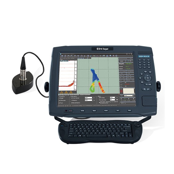
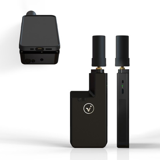
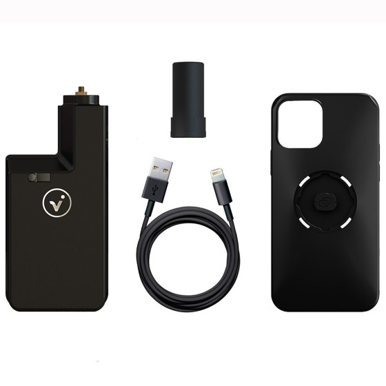
Pix4D viDoc RTK Rover
for selected iPhone and Android devices
The future of single point measurement with 3D scanning
Filter By
Brand
Brand
Price
Price
Use
Use
Horizontal circle
Horizontal circle
Magnification
Magnification
Single Prism Range
Single Prism Range
Reflectorless Range
Reflectorless Range
Accuracy at 1 km double leveling
Scope Magnification
Scope Magnification
Tripod Material
Tripod Material
Detectes
Detectes
Laser Beam
Laser Beam
Tilt Sensor
Tilt Sensor
Compatible with
Compatible with
Model
Model
Included Sensor
Included Sensor
Channels
Channels
UHF Radio modem
UHF Radio modem
Screen
Screen
Photo Resolution
Photo Resolution
Receiver for use with
Maximum Depth
Maximum Depth
Pole for use with
Pole for use with
Level Type
Level Type
Range
Range
Accuracy (mm to 10 meters)
Digital Pointfinder
Digital Pointfinder
Tripod Type
Tripod Type
Automatic Level Set
Automatic Level Set
Laser Type
Laser Type
P2P Package
P2P Package
Touchscreen
Touchscreen
Tripod connection 1/4"
Tether Length
Tether Length
IMU
IMU
Slope Setting
Slope Setting
Type
Type
Lock System
Lock System
Total Station Type
Total Station Type
Angle measurement accuracy
Meter
Meter
Working Range with Receiver Ø
Automatic End-Piece
Automatic End-Piece
Duty Type
Duty Type
Measurement Type
Measurement Type
Incorporated Laser Beam
Staff for use with
Staff for use with
Horizontal Levelling
Vertical Levelling
Vertical Levelling
Tripod Thread
Tripod Thread
Optical Plummet
Optical Plummet
Features
Features
for selected iPhone and Android devices
The future of single point measurement with 3D scanning
CHASING M2 PRO MAX is an industrial-grade underwater remote operated vehicle (ROV) designed for government and enterprise users. It is equipped with eight vectored thrusters, allowing 360-degree omnidirectional movements. The ROV can navigate at a maximum speed of 3 knots, dive to 200 meters deepwater, and move around a maximum horizontal radius of 400 meters.
SLAM-empowered lightweight handheld laser scanner for easy reality capture. Scan environments as you walk and create 3D models, floor plans and BIM. With an internal grip battery, it allows for a more balanced weight distribution, which not only enhances the overall using experience but also conforms to ergonomic principles.
HD-Lite echo sounder is a rugged and compact PC built-in professional portable echo sounder. Boosted by an upgraded sounder platform and enhanced hardware, HD-Lite provides users with a portable solution with accuracy and credibility.
CHASING Shore-based Power Supply System (C-SPSS) exclusively customized for CHASING M2 PRO and CHASING M2 PRO MAX, is featured by battery compartment design, enabling easy installation and a maximum output power of 1,500W, and ensuring that the ROV can work 24/7 at full power without power outage. The C-SPSS is provided 100m or 200m transmission cable to satisfy the demand of 24/7 operation in a wide range. Armed with a multiple protection system, the C-SPSS can guarantee the safety of users in operation.
Mapping and Digital Solutions Precision Locator Range
Locate and map buried utilities in a single operation with the RD8200SG - Survey Grade. The RD8200SG is our most advanced, combined mapping and utility locating solution that enables users to map buried utilities with survey grade accuracy.
Ready, Steady, Go.
DJI AGRAS T50 elevates drone agricultural operations to new heights. It inherits a powerful coaxial twin-rotor propulsion system and a split-type torque resistant structure for next level stability when carrying 40 kg spraying or 50 kg spreading payloads.
DJI AGRAS T50 leverages a Dual Atomizing Spraying System, Front and Rear Phased Array Radars, and a Binocular Vision System. DJI AGRAS T50 excels across multiple scenarios, from surveying to spraying and spreading, guaranteeing stable operations and steady performance.
Hi-Target HD-MAX dual-frequency echo sounder is universal in sediment measurement for dredging and other water depth measurement projects in shallow water, deep water and sandy water. The full-featured Hi-MAX Sounder hydrographic software integrates bathymetry, navigation, and post-processing. Equipped with the 17’’ large screen and industrial computer platform, HD-MAX offers a set of reliable solution for hydrographic offices around the world along with a robust dual-frequency transducer and a user-friendly survey pole.